Alto de Letras Bike Climb - PJAMM Cycling

67.7
PDI
49.9 mi
DISTANCE
12,749 ft
GAINED
4 %
AVG. GRADE

FULL CLIMB STATS

Page Contributor(s): Luke Hise, Phoenix, Arizona, USA

INTRO

Cycling Alto de Letras, Colombia - at  81.3 kilometers this is the third longest bike climb in the world behind #1 Mauna Loa, and #2 Wuling Pass East.  This is one of the greatest bike climbs in the world and worth traveling to Colombia to do. 

Our PJAMM Cycling Adventure App's preloaded Alto de Letras self-guided tour is accessed below. 


PLAN YOUR ROUTE

We've partnered with Sherpa-Map.com to bring you the best route planning tool. With a PRO Membership you can use this climb as a reference when creating your route.
This climb is about grade and altitude.  We have 3% less oxygen for every 300 meters of altitude gained during a ride.  At the top of Alto de Letras we have 36% less oxygen than at sea level.  The 4% average grade for the Alto de Letras bike climb is also terribly misleading - the true average grade after eliminating about 1,200 meters of descent on the climb is a daunting 7.5%.  27% (22 kilometers) of the climb is descent, 28% (22.3 km) at 0-5% grade, 26% (21 km) is at 5-10%, 13% (10.6 km) is at 10-15%, and 3.8% (3 km) is at 15-20%. 
Roadway:  Road quality is above average with the exception of several large pot holes that must be avoided on a potential descent. This is a tropical environment and one should expect some moisture on the route.

Traffic:  Mild to moderate.

Parking  Do not do this climb without support - not only does it take a long time to ride 80 kilometers gaining 4,400 meters, you also have to climb 1,200+ meters on the way back - that makes for a long day (see Full Summary).  If you are riding unsupported, you can park in town, or ride from your motel in Mariquita as we did. 
Provisions:  There are many roadside fruit stands and stores or cafes along the route. The town of Fresno has several cafes amenable to cycling.

Weather and Clothing:  You are finishing at high altitude 4,000 meters above your starting elevation.  Therefore, be sure to consult the PJAMM "Full Forecast" feature for the time you expect to arrive at the finish to assess what clothing to bring on your ride.

SAG:   We rode this one unsupported but recommend support. We have used the services of Colombia Bike Tours and they are magnificent - we vouch for them and will use their excellent services again when we return to this incredible cycling country.
Before heading out on any cycling adventure check out our Things to Bring on a Cycling Trip and use our interactive check list to ensure you don't forget anything.
Stay in Mariquita before you ride.  We stayed at Hotel Brisas La Gavota and highly recommend it.  We also recommend consulting Colombia Bike Tours before your trip as they may provide SAG for you. 

Strongly recommend riding with a guide. This is a lengthy climb subject to a multitude of changing weather patterns with significant traffic.

ROUTE MAP

MEMBER RATING

Difficulty: Extreme
5
Road
3
Traffic
4.5
Scenery

CURRENT WEATHER

PJAMM TRIPS ADVENTURE STARTER BUNDLES

Check out PJAMM Adventure's prepackaged (self-guided) cycling trips. They will help you plan, document and conquer your next adventure.
ALL TRIPS
Browse all of our prepackaged trips and find your next adventure!
Colombia: Alto de Letras
Colombia
2 ROUTES
10 POIs
ROUTE STATS (TOTAL)
49.9
mi
DISTANCE
12,750
ft
ELEV. GAIN

NEARBY CLIMBS (0) RADIAL PROXIMITY

FROM
No Climbs Found

MEMBER REVIEWS & COMMENTS

Let us know what you thought of this climb. Signup for our FREE membership to write a review or post a comment.
Already have an account?

Dec 20, 2021
difficulty: Extreme
scenery: 4
traffic: 3
road: 5
Dec 20, 2021
scenery: 4
traffic: 3
road: 5
This climb is long! Pavement is great and traffic isn't as bad as anticipated based off of what I read previously on this climb. There are no super steep sections and tons of descents to rest but the climb at 50 miles takes a toll on you. 5 hours without stopping is a long time. Beautiful scenery and a few places along the way to stop and grab a coffee or something to eat if you choose. One dangerous decent around the 48km mark is prone to mudslides and flooding so you need to be very careful. Most of the way up had wet roads but luckily it didn't do more than drizzle/ mist for me! With 20km to go it gets steeper and mixed with the altitude was definitely the hardest 10-15km of the climb. After that it's smooth sailing to the letras picture spot! A must do for a climber but if you don't want to stop along the way make sure to hire a SAG motorcycle for support. Tons of other bikers out there, trucks/ cars are pretty courteous and lots of honking and cheering support along the way.
Jan 11, 2022
How did you make that sticker???
Jan 11, 2022
I did the climb with Altos cycling tour group and they provided the sticker. Super helpful to know when a descent was coming up!
Aug 12, 2021
difficulty: Extreme
scenery: 5
traffic: 3
road: 5
Aug 12, 2021
scenery: 5
traffic: 3
road: 5
Epic climb! Beautiful scenery. Best to enlist the services of a local touring company for knowledge and support. I used Altos Cycling - great touring outfit out of Manizales. Early start (~6am) is best to escape the heat of Mariquita. I also found it best to break the climb up into segments of 10km vs segments of 10 mi. (I changed my computer settings to metric for the climb). Layers are essential (inc. rain gear) -- the cold and rain as you near the top can make you very cold FAST! At arrival, the town of Letras has plenty of places to warm your bones with the local aguapanela or hot chocolate.
ROUTE MAP
PROFILE TOOL
Route Data
S.G. (%)
hide
Segment Data
hide
CLIMB SUMMARY

Cycling Alto de Letras

Ride 50.5 miles gaining 14,526’ at 4% average grade (7.5% climb only)

Colombia #2 road bike climb (behind El Limonar) and in the World Top 100.

Climb summary by PJAMM’s John Johnson.

This is an extremely difficult out-and-back and we do not recommend that.  If you do go for the out-and-back, beware that there is 4,025’ of descent on the “out” which means 4,025’ ascent on the “back” the sum of which is 18,551’ climbing day.   The 14,526’ gained on this ascent is the second most of any other climb in the world only slightly behind Ecuador’s La Muerta at 14,670’.

50.5 miles (third longest bike climb in the world)

#1 Mauna Loa, USA (62.2 miles); #2 Wuling East, Tawan (54.3 miles)

And the top two adjectives to describe this climb are:   Long and Lush.  

See also - Luke Hise, Phoenix, AZ, USA Summary Here.

Beginning of Alto de Letras road bike climb - Mariquita.

We stayed at a very nice hotel in Mariquita -

 Hotel Brisas La Gaviota - highly recommended.

Luke Hise also has a recommendation from his stay:  “We stayed in the Casa Marilla, Casa de Huespedes (casamarilla.com.co) in Mariquita. It was without air conditioning but I would recommend it heartily for anyone looking for a more local flavor. The Best Western, this was not. Ha.”

Beginning of Alto de Letras road bike climb - Mariquita.

PJAMM leaving the hotel in Mariquita and the start of the climb on Hwy 50, Mariquita.

Beginning elevation 1,585’

 The climb is also very, very long (third  longest in the world behind Mauna Loa from the Kona side and Wuling Pass East).  It is a bit of a trek to get to - we fly first to Bogota (there are many nonstop inexpensive flights from the U.S. and even Europe [Heathrow has nonstop to Bogota], but most travel from Europe requires a layover), then drive 175 km/110 miles to Mariquita where the climb begins.

Photos from Luke Hise’s (Phoenix, AZ) January, 2021 trip.

The roadway is in excellent condition, has a shoulder for the most part and, while it does have a fair amount of traffic, felt safe to us, in spite of the fairly dramatic road warning signs we saw along the way.

Climbing Alto de Letras by bike - roadway and big trucks.

O.k. - there is a bit of traffic along this route.  

 Bicycle ride up Hwy 50 to Alto de Letras - crazy driver sign

Not sure if that is a statement or warning . . . ?

Be prepared for the altitude as this one rises to nearly 12,000’.  Since this climb is generally known (incorrectly) as the longest road in the world, it does get a fair amount of foreign cycling traffic, and rightly so.  However, beware that it is very difficult for an average rider to do this trip in one day as an out and back because its length and because there is nearly 3,000’ of climbing on the way back - it is a 100 miles 15,000’ day riding to the top from Mariquita then back to the start.

Many roadside fruit stands and little cafés along the way.

Much agriculture in this part of the country

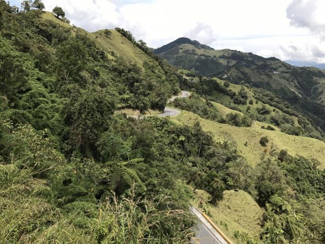
Beautiful scenery along the route.

Cattle on Alto de Letras cycling climb Hwy 50

Colombian camouflage . . .

Colombian coffee fields

Riding through the narrow streets of Fresno at km 25

Founded 1574; elevation 1,465 m (4,806’) population 30,750 (2005).

Long and windy road that is very steep in sections.

Finish of Alto de Letras road bike climb

82 km later . . .

John Johnson and Will Plaugher at finish of Alto de Letras bike ride.

That was ONE HECK OF A RIDE!

We mistimed the our return ride and misjudged the weather

Javier was kind enough to give us a ride back from Fresno.

Steepest Gradients by Distance

Grades.JPG

We stayed at Hotel Brisas la Gaviota in Mariquita - the hotel is very nice, reasonable priced and just a couple kilometers from the start.  It is down some fairly obscure back roads, so be sure to have good GPS to assist you in navigating to this hotel.

Colombia Bike Tours: if you are interested in a cycling tour in the wonderful country of Colombia - info@colombiabiketours.cc   We have used this company and they are exceptional - we highly recommend using hiring them if you are interested in cycling in Colombia.